In July and August 2012, the RV Keary and RV Geo spent several weeks mapping the seabed around Inishbofin, Inishturk and Killary Harbour. The vessels were based in Inishbofin harbour for the duration of the survey.
Initially, two specific sites were mapped for BIM (Bord Iascaigh Mhara) who are investigating the potential of deep-water aquaculture sites in the area. In addition, a larger area around the islands was mapped to provide bathymetric data for oceanographic current modelling to be carried out by the Marine Institute, along with extending INFOMAR coverage into the area around the islands.
The survey data revealed very interesting underwater topography, containing extensive rocky outcrop, fault lines and sedimentary features.
Below are images of the survey coverage and the vessels at work. Note that the colour scales may vary between the survey coverage images - the red and blue ends of the spectrum represent shallower and deeper water, respectively.
Survey coverage by RV Keary and RV Geo around Inishbofin and Inishturk. The RV Geo carried out the shallower water mapping along the coastlines. Data in this image is still in the process of being finalised and contains some errors.
The "Stags" rocks off the NW coast of Inishbofin.
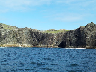
A view of Inishturk's rugged coastline from the RV Geo.
RV Keary.
A backscatter map of the seabed around Inishbofin and Inishturk, merged with a shaded relief map. Backscatter maps are produced from the strength of the sound waves returning to the multibeam sonar, having reflected off the seafloor - this provides information on seafloor hardness, which is then represented in greyscale here (darker shades represent harder seabed). The grey polygon in the centre and eastern part of the map represents the extent of seabed previously mapped by the RV Celtic Explorer.
Folded rock strata on Inishturk's coastline. The onshore geology on both islands is complex and ancient - the seabed mapping carried out during the survey should help to extend the understanding of it into the offshore environment.
RV Keary transiting from Inishbofin to Cleggan.
RV Keary tied up alongside Inishbofin's ferry, the Island Discovery, in Inishbofin harbour.
Structural geology of Inishturk, with seabed coverage by RV Keary and RV Geo around the island. Onshore, faults are shown in black and the synclinal axes of folded strata are shown in red. The fault marked with the red arrow appears to extend offshore in a south-easterly direction as a discontinuity in the seabed rock outcrop.
Along with successfully acquiring bathymetric data, the INFOMAR vessels completed inshore mapping around Inishbofin and Inishturk - the data will be freely available in several formats on the INFOMAR website in the future.
Thursday 1 November 2012
Subscribe to:
Posts (Atom)


